Geography archived articles

Subscribe to the RSS feed for this category only

Consumption and Cycling and Geography and Photography07 Apr 2010 at 12:07 by Jean-Marc Liotier

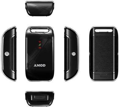
One fellow mapper on talk-fr@openstreetmap.org complained that there was very few comments about the Amod AGL 3080 GPS logger from other OpenStreetMap users… So here is one.

I liked my trusty Sony GPS-CS1 GPS logger, but autonomy of barely more than a good riding day was too short for my taste and the one Hertz sampling rate was too low for satisfactory OpenStreetMap surveying by bicycle or roller-skate, though it was plenty for walking.

After sifting through various reviews and specification sheets, I declared the Amod AGL 3080 the true heir to the Sony GPS-CS1. And after a few months of use I am not disappointed.

AMOD AGL 3080 GPS logger

This solid little unit is simple to use : normal operation requires a single button. After mounting as USB mass storage with a standard mini-USB cable, a pass trough GPSbabel is all that is needed before the data is ready for consumption. There is also a handy second button for marking waypoints – I use it mostly to record points of interests. The AGL 3080’s SiRF Star III chipset provides satisfactory reception – subjectively much better than the GPS-CS1’s, and the storage capacity is more than you will need for anything up to a transcontinental ride. It uses three AAA batteries, which makes it practical for underway replenishment while making the use of rechargeables possible too. For a walkaround, PocketGPSWorld has a review with detailed pictures.

But what I appreciate most is the ability to configure the output NMEA sentences for the best compromise between autonomy and the richness of the of logged data. 6 logging modes can be by cycled through by pressing the “MARK” button for as much precision or as much battery life as you wish to adjust as you go :

Mode LED Status Output format Interval (seconds) Records Duration (hours)
1 “Memory
Full” on
GGA/GSA/RMC/VTG 1 260 000 72
GSV 5
2 “Memory Full” flash Only
RMC
1 1 040 000 288
3 “GPS” on GGA/GSA/RMC/VTG/GSV 5 260 000 360
4 “Battery Low” on Only
RMC
5 1 040 000 1440
5 “Battery Low” on GGA/GSA/RMC/VTG/GSV 10 260 000 720
6 “Battery Low” flash Only RMC 10 1 040 000 2880

The not so good is that the absence of rubber gasket on the battery compartment hints that this device is not waterproof. Like the Sony GPS-CS1 it has been through rain with no apparent problem, but pushing my luck too far will probably result in corrosion.

The ugly is that I have yet to find a way to strap the Amod AGL 3080 securely. It features a strap slot on only one side, making any balanced setup impossible. Supplied Velcro strap can connect it to a carabiner, but the resulting contraption dangles around wherever you attach it – I hate to have dangling things attached to my kit. The Sony GPS-CS1has a pouch that features a convenient Velcro strap to conveniently attach it to a any strap – I use it on top of my backpack’s shoulder straps or on top of my handlebar bag. The Amod AGL 3080 has nothing like that and I have yet to find a good way to mount it on my bicycle – for now, rubber-bands are the least worst option.

But for 70 Euros, it is a bargain if you need a cheap, simple and flexible GPS logger for photography, sports or cartography. Buy it – and then tell me if how you succeeded in mounting it on a bicycle or on a backpack !
Free software and Geography and Marketing and Politics and Technology and The Web17 Dec 2009 at 13:27 by Jean-Marc Liotier

The quality of OpenStreetMap‘s work speaks for itself, but it seems that we need to speak about it too – especially now that Google is attempting to to appear as holding the moral high ground by using terms such as “citizen cartographer” that they rob of its meaning by conveniently forgetting to mention the license under which the contributed data is held. But in the eye of the public, the $50000 UNICEF donation to the  home country of the winner of the Map Maker Global Challenge lets them appear as charitable citizens.

We need to explain why it is a fraud, so that motivated aspiring cartographers are not tempted to give away their souls for free. I could understand that they sell it, but giving it to Google for free is a bit too much – we must tell them. I’m pretty sure that good geographic data available to anyone for free will do more for the least developed communities than a 50k USD grant.

Take Map Kibera for example :

“Kibera in Nairobi, Kenya, widely known as Africa’s largest slum, remains a blank spot on the map. Without basic knowledge of the geography and resources of Kibera it is impossible to have an informed discussion on how to improve the lives of residents. This November, young Kiberans create the first public digital map of their own community”.

And they did it with OpenStreetMap. To the million of people living in this former terra incognita with no chance of profiting a major mapping provider, how much do you think having at last a platform for services that require geographical information without having to pay Google or remain within the limits of the uses permitted by its license is worth ?

I answered this piece at ReadWriteWeb and I suggest that you keep an eye for opportunities to answer this sort of propaganda against libre mapping.

Economy and Geography and Mobile computing and Networking & telecommunications02 Nov 2009 at 20:31 by Jean-Marc Liotier

Valued Lessons wrote :

A lot has been written lately about Google Maps Navigation. Google is basically giving away an incredible mapping application with good mapping data for free. Why would they do such a thing? Most of the guesses I’ve seen basically say “they like to give stuff away for free to push more advertisements”. That’s close, but everyone seems to have missed a huge detail, perhaps the most important detail of all.

Google is an advertisement company, particularly skilled at targeted advertisements. Almost all of their revenue comes from being able to show you ads that you want to see when you want to see them. What does this have to do with maps and navigation? Well, this is going to seem really obvious once you read it, but no one seems to have mentioned it yet, so here it goes:

Google will know everywhere you drive, and when.

Valued Lessons goes on to detail ways Google could use that data to refine the targeted advertisement that represents the lion’s share of Google’s revenue. But there is another reason for pushing Google Navigation…

Now that they have found the way to gather start harvesting the data at a really massive scale they are able to go head to head with all the navigation software editors that have provide traffic information. Here is a nice business model :

  • Get the free version of Google Navigation deployed to as many terminals as possible.
  • Harvest traffic data.
  • Sell traffic data as a premium service. Or just give it away and kill everyone else…

Mobile network operators I know are going to hate this. They make partnerships with the likes of TomTom, only to be entirely bypassed by Google ! I love it.

Let’s take a look at what TomTom wanted to do :

TomTom will use two main sources of information, occasionally complemented by others.

First, travel times deduced from the movement patterns of mobile phones. TomTom has made an agreement with Vodafone NL, allowing us to use (anonymously) the country’s 4 million Vodafone customers as a potential source of information and developed the technology to transform this monitoring information from the mobile network into reliable travel time information.

Secondly, historical FCD (Floating Car Data) from our own customers. Every TomTom navigation system is equipped with a GPS sensor, from which one can determine the exact location of a car.

Yes, Google can do all that too.

The process of obtaining data TomTom has developed results in highly detailed traffic information. In the Netherlands, for example, it means up-to-date travel times per road segment for approximately 20,000 km of road (see figure) and historical information per road segment for all major roads in the country, approximately 120,000 km.

TomTom has developed the technology in-house to calculate travel times across the entire road network, by processing the monitoring data from the mobile telephone network through TomTom’s Mobility Framework software.

And that’s information from before 2007… Imagine what can be done today !

Letting Google know where you go and letting Google mine that data is the reason for Google Latitude too… Latitude does not have the same mainstream appeal as a turn by turn navigation application, but with so many Google Maps customers now using it inside their car we are now talking Google scale !

Geography and Mobile computing and Networking & telecommunications and Technology30 Oct 2009 at 12:42 by Jean-Marc Liotier

Last week-end I ventured outside of the big city, in the land where cells are measured in kilometres and where signal is not taken for granted. So what surprised me was not to have to deal with only the faint echo of the network’s signal. Cell of origin location on the other hand was quite a surprising feature in that environment : sometimes it works with an error consistent with the cellular environment, but often the next moment it estimated my position to be way further from where I actually was – 34 kilometres west in this case.

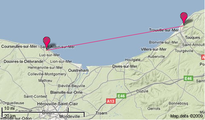
The explanation is obvious : my terminal chose to attach to the cell it received best. Being physically located on a coastal escarpment, it had line of sight to a cell on the opposite side of the bay – 34 kilometres away.

But being on the edge of a very well covered area, it was regularly handed over to a nearby cell. In spite of the handover damping algorithms, this resulted in a continuous flip-flop nicely illustrated by this extract of my Brightkite account’s checkin log :

Isn’t that ugly ? Of course I won’t comment on this network’s radio planning and cell neighbourhood settings – I promised my employer I will not mention him anymore. But there has to be a better way and my device can definitely do something about it : it is already equipped with the necessary hardware.

Instant matter displacement being highly unlikely for the time being, we can posit that sudden movement of kilometre-scale distances will result in the corresponding acceleration. And the HTC Magic sports a three axis accelerometer. At that point, inertial navigation immediately springs to mind. Others have thought about it before, and it could be very useful right now for indoor navigation. But limitations seem to put that goal slightly out of reach for now.

But for our purposes the hardware at hand would be entirely sufficient : we just need rough dead reckoning to check that the cell ID change is congruent with recent acceleration. With low quality of the acceleration measurement, using it as a positioning source is out of question, but it would be suitable for dampening the flip flopping as the terminal suffers the vagaries of handover to distant cells.

So who will be the first to refine cell of origin positioning using inertial navigation as a sanity check ?

Geography and Knowledge management and Mobile computing and Technology30 Aug 2009 at 21:30 by Jean-Marc Liotier

As the Geohack template used by Wikipedia for geographical locations attests (see Paris for example) there are many map publishing services on the Web. But almost all of them rely on an oligopoly of geographical data suppliers among whom AND, Navteq and Teleatlas dominate and absorb a large proportion of the profit in the geographical information value chain :

“If you purchase a TomTom, approximately 20-30% of that cost goes to Tele Atlas who licenses the maps that TomTom and many other hardware manufacturers use. Part of that charge is because Tele Atlas itself, and the company’s main rival Navteq, have to buy the data from national mapping agencies in the first place, like the Ordance Survey, and then stitch all the information together. Hence the consumer having to pay on a number of levels”.

And yet, geographical data is a fundamental pillar of our information infrastructure. A few years ago the realm of specialized geographic information systems, geography is nowadays a pervasive dimension of about every sort of service. When something becomes an essential feature of our lives, nothing short of freedom is acceptable. What happens when that freedom requires collecting humongous amounts of data and when oligopolistic actors strive to keep control and profits to themselves ? Free software collaboration and  distributed data collection of course !

Andrew Ross gives a nice summary of why free geographical data is the way of the future :

“The tremendous cost of producing the maps necessitates that these firms have very restrictive licenses to protect their business models selling the data. As a result, there are many things you can’t do with the data.

[..] The reason why OpenStreetMap will win in the end and likely obviate the need for commercial map data is that the costs and risks associated with mapping are shared. Conversely, for Navteq and TeleAtlas, the costs born by these companies are passed on to their customers. Once their customers discover OpenStreetMap data is in some cases superior, or more importantly – they can contribute to it and the license allows them to use the data for nearly any purpose – map data then becomes commodity”.

The proprietary players are aware of that trend, and they try to profit from the users who wish to correct the many errors contained in the data they publish. But why would anyone contribute something, only to see it monopolized by the editor who won’t let you do what you want with it ? If I make the effort of contributing carefully collected data, I want it to benefit as many people as possible – not just someone who will keep it for his own profit.

Access to satellite imagery will remain an insurmountable barrier in the long term, but soon the map layers will be ours to play with – and that is enough to open the whole world of mapping. Like a downhill snowball, the OpenStreetMap data set growth is accelerating fast and attracting a thriving community that now includes professional and institutional users and contributors. Over its first five years, the Wikipedia-like online map project has delivered great results – and developed even greater ambitions.

I have started to contribute to OpenStreetmap – I feel great satisfaction at mapping the world for fun and for our common good. Owning the map feels good ! You can do it too – it is easy, especially if you are the sort of person who often logs tracks with a GPS receiver. OpenStreetMap’s infrastructure is quite impressive – everything you need is already out there waiting for your contribution, including very nice editors – and there is one for Android too.

If you just want to add your grain of sand to the heap, reporting bugs and naming the places in your favourite neighbourhood are great ways to help build maps that benefit all of us.  Contributing to the map is like giving directions to strangers lost in your neighbourhood – except that you are giving directions to many strangers at once.

If you are not yet convinced, take a look a the map – isn’t it beautiful ? And it is only one of the many ways to render OpenStreetMap data. Wanna make a cycling map with it ? Yes we can ! That is the whole point of the project – we can do whatever we want with the data, free in every way.

And anyone can decide he wants his neighbourhood part of the worldmap, even if no self-respecting for-profit enterprise will ever consider loosing money on such endeavour :

“OpenStreetMap has better coverage in some niche spaces than other mapping tools, making it very attractive resource for international development organizations. Want proof ? [..] we looked at capital cities in several countries that have been in the news lately for ongoing humanitarian situations – Zimbabwe, Somalia, and the Democratic Republic of the Congo. For two our of the three, Mogadishu and Kinshasa, there is simply no contest – OpenStreetMap is way ahead of the others in both coverage and in the level of detail. OpenStreetMap and Google Maps are comparable in Harare. The data available through Microsoft’s Virtual Earth lagged way behind in all three”.

Among other places, I was amazed at the level of detail provided to the map of Ouagadougou. Aren’t these exciting times for cartography ?

If you purchase a TomTom, approximately 20-30% of that cost goes to Tele Atlas who licenses the maps that TomTom and many other hardware manufacturers use. Part of that charge is because Tele Atlas itself, and the company’s main rival Navteq, have to buy the data from national mapping agencies in the first place, like the Ordance Survey, and then stitch all the information together. Hence the consumer having to pay on a number of levels.