Inertial navigation as a CellID sanity check
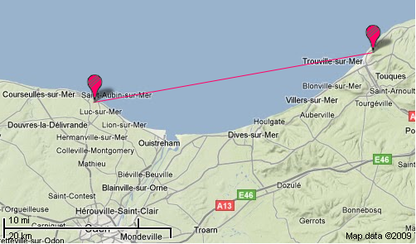
Last week-end I ventured outside of the big city, in the land where cells are measured in kilometres and where signal is not taken for granted. So what surprised me was not to have to deal with only the faint echo of the network’s signal. Cell of origin location on the other hand was quite a surprising feature in that environment : sometimes it works with an error consistent with the cellular environment, but often the next moment it estimated my position to be way further from where I actually was – 34 kilometres west in this case.

The explanation is obvious : my terminal chose to attach to the cell it received best. Being physically located on a coastal escarpment, it had line of sight to a cell on the opposite side of the bay – 34 kilometres away.
But being on the edge of a very well covered area, it was regularly handed over to a nearby cell. In spite of the handover damping algorithms, this resulted in a continuous flip-flop nicely illustrated by this extract of my Brightkite account’s checkin log :

Isn’t that ugly ? Of course I won’t comment on this network’s radio planning and cell neighbourhood settings – I promised my employer I will not mention him anymore. But there has to be a better way and my device can definitely do something about it : it is already equipped with the necessary hardware.
Instant matter displacement being highly unlikely for the time being, we can posit that sudden movement of kilometre-scale distances will result in the corresponding acceleration. And the HTC Magic sports a three axis accelerometer. At that point, inertial navigation immediately springs to mind. Others have thought about it before, and it could be very useful right now for indoor navigation. But limitations seem to put that goal slightly out of reach for now.
But for our purposes the hardware at hand would be entirely sufficient : we just need rough dead reckoning to check that the cell ID change is congruent with recent acceleration. With low quality of the acceleration measurement, using it as a positioning source is out of question, but it would be suitable for dampening the flip flopping as the terminal suffers the vagaries of handover to distant cells.
So who will be the first to refine cell of origin positioning using inertial navigation as a sanity check ?
3 responses to “Inertial navigation as a CellID sanity check”
Leave a Reply
You must be logged in to post a comment.
You may be entitled to claim a world record for finding the worst place for cell based location measurement. :)
The problem I find with your sanity check is that it relies on pretty “high-end” sensory data. I would assume those devices would contain already GPS which would be used instead. Not perhapse inside a building where the inertial navigation sanity check could be applicable on smaller scale, e.g. flip-flopping between GSM-3G cell.
On the other hand, I was thinking that could cell id databases such as opencellid.org contain data (other than accuracy) which would descibe the likelyhood that there might happen such a flip-flop case. This would enable users to define algorithms where they could filter out at least sometimes these error cases.
[…] Liotier kirjoittelee blogissaan pienehköstä sijaintiinsa liittyneestä mittausvirheestä. Ollessaan matkalla Ranskan rannikolla […]
Of course, a clear view of the sky makes GPS the most practical source unless your application is weapon guidance. The inside building case is what I had in mind, especially as indoors is the new frontier for hand held navigation.
I wonder if inertial measurement components will become cheap enough for mass consumption. The spread of PDA and Wiimotes hints that we may have such luck in the coming years.